Featured amenities
 Pet Friendly
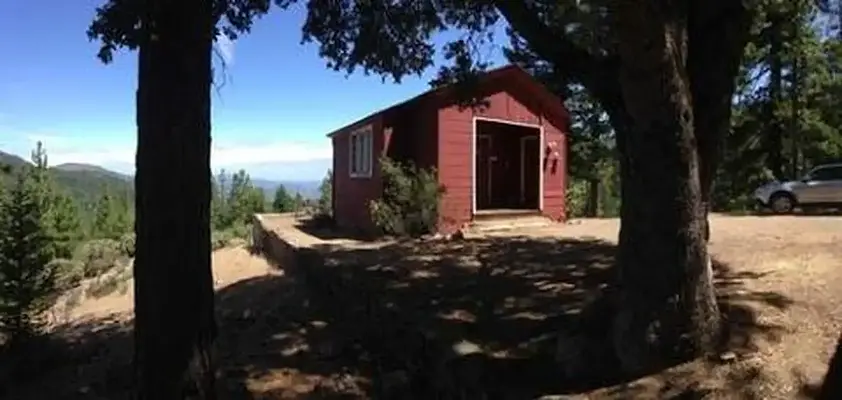
About Post Creek Guard Station
Number of accommodations: 1
Seasonal information
2026 Season availability
Campground Amenities
Most popular amenities
Pet friendly

Pets and Policies
- Pet friendly
Report Incorrect Information
Help us improve by reporting any incorrect amenity information for Post Creek Guard Station.

001, Loop: AREA POST CREEK GUARD STATION
Site Details
Reviews (38)
What Guests Are Saying
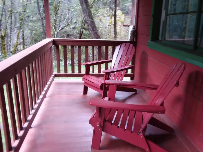
Post Creek Guard Station offers a clean, well-equipped cabin with stunning views and a peaceful atmosphere, perfect for those seeking tranquility in nature. Guests appreciated the well-maintained access roads and amenities such as running water and a flush toilet. While there are some wasp nests to be cautious of and limited attractions, many visitors plan to return for longer stays to explore the surrounding hiking opportunities.
What Guests Are Saying
Post Creek Guard Station offers a clean, well-equipped cabin with stunning views and a peaceful atmosphere, perfect for those seeking tranquility in nature. Guests appreciated the well-maintained access roads and amenities such as running water and a flush toilet. While there are some wasp nests to be cautious of and limited attractions, many visitors plan to return for longer stays to explore the surrounding hiking opportunities.
Review Summary
Rebecca S
VerifiedAugust 4, 2025 • Stayed at: 001, Loop: AREA POST CREEK GUARD STATION
Incredible spot! We took Tedoc Road (option 2) up and it was one of the best maintained forest service roads I have ever driven on. The cabin was very clean and we saw/heard no signs of mice although we did not open the silverware drawers (ignorance is bliss). The views and stars from the cabin were amazing! There are a few wasp nests in the entrance to the cabin and a couple were hanging around the gate, so be mindful when you pull the pin to open the gate. Will definitely be planning to return for a longer stay to check out more of the hiking in the area. Thank you USFS!!!!
Donald E
VerifiedJune 26, 2025 • Stayed at: 001, Loop: AREA POST CREEK GUARD STATION
Well equipped guard station with beautiful views of the surrounding forests and mountains. Quiet and secluded area that takes you up winding gravel roads for a couple hours. Guests afraid of heights and those with low clearance vehicles might steer clear of the challenging drive. It’s really worth the extra effort as long as you’re patient and have all your food and drinking water.
Caitlin M
VerifiedSeptember 17, 2024 • Stayed at: 001, Loop: AREA POST CREEK GUARD STATION
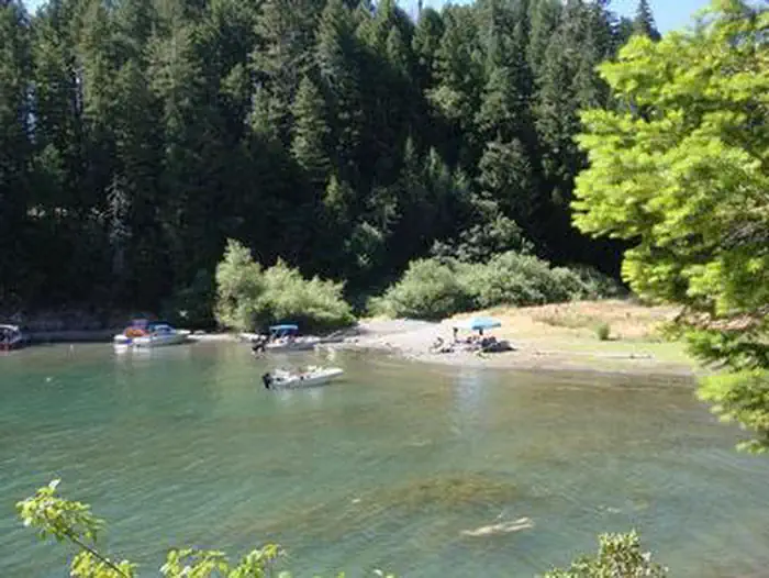
Third fire lookout I've stayed at. Great view, stars are awesome at night and the running water and bathroom inside was definitely a plus! The swimming hole was refreshing and there was lots to explore.
Caitlin M
VerifiedSeptember 17, 2024 • Stayed at: 001, Loop: AREA POST CREEK GUARD STATION
Third fire lookout I've stayed at. Great view, stars are awesome at night and the running water and bathroom inside was definitely a plus! The swimming hole was refreshing and there was lots to explore.
Caroline K
VerifiedJuly 30, 2024 • Stayed at: 001, Loop: AREA POST CREEK GUARD STATION
First time visitors to this spot. What a peaceful place! The cabin is comfortable, well stocked and nicely maintained. Having running water (non-potable) and a flush toilet is luxury in my book. The kitchen has everything, even a propane stove and gas (we brought and used our own). There was no lock on the gate (just on the cabin). When my partner reached into the pipe at the gate for the lock (we didn't know it wasn't there) he got stung by a wasp nesting in there (be aware). There is an outdoor shower stall behind the garage. We hung a water bag there for a quick rinse. The swimming hole was too cold for us, and the size/water level doesn't really allow for actual swimming.
Regarding the road conditions: on the way in the mapping app took us on the left fork (if driving south on Tedoc road) at these coordinates: 40°16'51.5"N 122°52'51.4"W. Unless you have a 4WD rig with extra clearance, I suggest to not take that left fork. Stick to the right - it's a MUCH better road.
It was so quiet at the Guard Station - over the four days we saw four cars, all parked at trailheads. No one on the roads. The area burnt a few years ago, so it is not as scenic as I assume it once was. We did one nice hike to Black Rock Lake, and visited the abandoned White Rock Guard Station another day. There are not a whole lot of 'attractions' but if you're looking for serenity - this is a great place to find it.
Wildlife sightings included a Pileated Woodpecker, Black-Headed Grosbeaks, Townsend Solitaires, mule deer and a momma bear with two cubs (not at the guard station). Big thank you to the Forest Service for maintaining this sweet spot!
William C
VerifiedNovember 17, 2023 • Stayed at: 001, Loop: AREA POST CREEK GUARD STATION
A remote lookout with spectacular views from the sleeping area; 2 queen foam mattress beds. Flush toilet and running water to wash dishes. Some electric camping lamps but you should plan to bring AA batteries. There was a mouse nest in the silverware drawer. Screens were somewhat effective but lots of flies inside. I had an electric flyswatter and got rid of them in 15 minutes!
The trip up was a bit harrowing in a VW ID.4 EV but I was able to drive up and back with a 100% charge at Anderson, CA. The road had several trees fallen into the road and at one point I had to get out and move them out of the way. Another required careful manuvering to avoid hiiting the tree on one side and slipping off the road on the other. Watch out for big rocks in the road.
Note that when you turn onto the final stretch of gravel road (look for sign stating 28N36 4POST .CR), it is almost exactly 4.1 miles to the gate. You cross a bridge that is NOT Post Creek and there is a LOCKED green gate on the right that is NOT the entrance. You go up several steep inclines and it is on the LEFT. The ROAD CLOSED sign on the gate is completely faded but it is attached to the gate.
It was well worth the trip up but as noted before, it is a burn area with downed trees and very little green vegetation at this time. Perhaps in 5 - 10 years it will return to its previous glory.
Location Post Creek Guard Station
Address:
Weaverville Ranger Station
Weaverville, CA, 96093
United States
From I-5, take California State Highway 36 West. From US-101 take California State Highway 36 East. Once on CA-36, there are two options. Option 1 is a bit longer but the majority of the trip is on paved Forest roads. Option 2 is shorter, but all of the trip is on gravel Forest roads. Call the Ranger Station before you go for more information on road conditions. DO NOT rely on any sort of GPS devices or online mapping programs to get you to Post Creek Guard Station. They are not accurate and may get you lost. There is no cell service at the cabin or on the roads leading to it. Make sure you have accurate directions before leaving home.
Option 1 - From CA-36, turn south (left if coming from the east; right if coming from the west) onto Forest Road 30 (29N30), also known as Wild Mad Road. Follow Forest Road 30 until it intersects with Forest Road 35 at Pine Root Saddle (approximately 8 miles). Turn left on Forest Road 35. Continue on Forest Road 35 until it intersects with Forest Road 28N10 (approximately 11 miles; if you get to Stuart Gap, you have gone just slightly too far). All roads are paved until this point where the roads become gravel. Turn left on Forest Road 28N10. Go less than a mile and turn right on Forest Road 28N36 - watch carefully for this junction and do not miss it! Continue on Forest Road 28N36 for approximately 4 miles). You will drive through private property and then over Post Creek about 1/4 mile from the cabin. Turn south at the green gate which states "Road Closed". Open gate, and drive through to the cabin.
Option 2 - From CA-36, turn south (left if coming from the east; right if coming from the west) onto Forest Road 45 (29N45), also known as Tedoc Road. This is a gravel road. Continue to the intersection with Forest Road 28N36 (approximately 12.5 miles). At the intersection of the 27N13, 28N05, and 29N45 roads, be sure to verr to the right to stay on the 29N45 road. Turn right on 28N36 and follow it until you see the green gate on the right (not quite 2 miles. Turn right at the green gate which states "Road Closed". Open gate, and drive through to the cabin.
Post Creek Guard Station is accessible via California State Highway 36, which connects to I-5 to the south and US-101 to the west.
Latitude & Longitude: 40.2333 / -122.917
Elevation: 1413 feet
Policies & Rules
Cancellation policy
- Reservation fees are non-refundable. For campsites, cabins, lookouts, yurts, group sites, and similar stays, we charge a reservation service fee of $8.
- Standard cancellations usually have a $10 cancellation fee. Customers can generally cancel before the check-in date online.
- Late cancellation rules differ by stay type.
- Individual campsites: cancelling after 12:00am local time the day before arrival usually means a $10 cancellation fee plus forfeiting the first night's fee.
- Cabins, lookouts, and yurts: cancelling less than 14 days before arrival usually means a $10 cancellation fee plus forfeiting the first night's fee.
- One-night reservations: a late cancellation usually forfeits the full amount paid, up to the total original reservation cost.
- Modifications are allowed before the cut-off window, but fees depend on the change. Changing to dates completely outside the original reservation dates may trigger a $10 change fee. Extending or shortening a stay that still includes original dates usually has no change fee, though refunds may depend on timing and facility rules. Switching to the same type of campsite for the same dates usually has no change fee, but price differences are charged or refunded.
- Early departures may or may not be refunded. At certain facilities, partial refunds may be possible if staff can mark the site available for other visitors. No refund is given for a night if the early departure is requested after that day's check-out time.
- Security deposits are separate. Security deposits may be refunded to the original payment method if the facility is left in acceptable condition, as determined by the property.
Nearby Campgrounds
Last updated: July 11, 2026