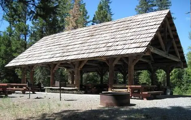
MAGONE LAKE-GROUP PICNIC SHELTER
MAGONE LAKE

About Magone Lake

Magone Lake Campground is situated along its namesake lake in the northern reaches of Malheur National Forest in the Blue Mountains of eastern Oregon. Visitors enjoy fishing, canoeing, swimming and hiking.

Seasonal information

2026 (Current year)

2026 Season availability

Current season
Upcoming seasons
Past seasons
Closed periods
Jan
Feb
Mar
Apr
May
Jun
Jul
Aug
Sep
Oct
Nov
Dec
Currently open - May 8 to Oct 31

Campground Amenities

Water and Hygiene

Water and Hygiene

  • Potable Water
Water Access

Water Access

  • Beach Access
Missing information?

01, Loop: GCG

🚐 RV
  • Pet Friendly
  • Paved
  • Driveway entry: Back-In

Site Details

Up to 75 guests
Shade
Surface: Paved
Driveway entry: Back-In
Pet Friendly
Accessible
View Site Details

Reviews

15 reviews

Summary

AI generated

Magone Lake offers a clean and quiet group area that accommodates large gatherings comfortably. The well-maintained restrooms and provided firewood enhance the camping experience. It's a highly recommended site, just a short drive from the lake.

Based on guest feedback

4.4

Overall rating

Based on 15 reviews

Write a review
5 stars 73.3% (11)
4 stars 0.0% (0)
3 stars 20.0% (3)
2 stars 6.7% (1)
1 star 0.0% (0)

Showing 15 reviews

John Y

Verified

June 20, 2026 Stayed at: 01, Loop: GCG

Helpful
John Y

Verified

June 20, 2026 Stayed at: 01, Loop: GCG

Helpful

John Y

Verified

June 20, 2026 Stayed at: 01, Loop: GCG

Helpful

Alan S

Verified

September 21, 2026 Stayed at: 01, Loop: GCG

I very much appreciated the camp hosts. They were a pleasure to talk with; had good information and were very much on top of their routine. Our campers even commented on how the cleanliness of the campsite/toilets.

Helpful

Debbie W

Verified

September 27, 2026 Stayed at: 01, Loop: GCG

The campground was adequate. Water had to be boiled. Tent sites could be bigger and more level. A covered shelter would have been nice. We got rained on dueing supper the first evening. Otherwise I loved that it was a sunny spot with trees sureounding it for a sept. Campout.

Helpful

Location & Directions for Magone Lake

431 Patterson Bridge Rd, John Day, OR 97845 United States

Elevation: 1,530 ft

Getting There

From John Day, Oregon, take U.S. Highway 26 east for approximately 9 mi. At the junction of County Road 18, travel north approximately 10 mi. At Forest Road 3620, turn left and drive approximately 1 mi to Forest Road 3618. The campground is 1 mi f...

Nearest town

John Day, OR - 25 mi

About 36 min to downtown

Highway access

Magone Lake is accessible via U.S. Highway 26, which is approximately 9 miles east of John Day and 3 miles west of Prairie City.

Policies & Rules

General

  • No hookups available.
  • Click here for more information on the Malheur National Forest.
  • Check out the forest's campground description for specific information to Fish Your National Forest.
  • Don't Move Firewood: Please protect Pacific Northwest forests by preventing the spread of invasive species. Firewood can carry insects and diseases that can threaten the health of our western forests. You can make a difference by obtaining and burning your firewood near your camping destination. Visit Dontmovefirewood.org for further information.
  • Campers and day users must bring garbage bags. This is a pack it in pack it out facility.
  • A $5.00 fee will be charged at the campground for each additional vehicle.
  • Magone Lake Campground is in a remote forest location with very limited or no mobile phone coverage.
  • Drinking water is available only during warmer months; water will be shut off from early to mid-October until mid to late May (specific dates required to prevent freezing depend on area temperatures).
  • The GROUP CAMPSITE has a locked gate to prevent those without reservations from entering the site before or during reserved periods. The lock combination is issued as a part of the reservation confirmation email. Please arrive prepared with the combination. A campground host may be available during the summer season, and the ranger district offices have the combination information available. It is the responsibility of visitors to arrive prepared to enter the group site. Thank you.
  • The PICNIC SHELTER has a gate that can be closed as needed, but typically remains open. If the shelter is unreserved the public may access and use this space. If there is a reservation, campground hosts or USFS staff may attend to this gate. Th picnic shelter gate does not have a combination lock. The GROUP PICNIC SHELTER IS DAY USE. No overnight camping. 

Nearby Campgrounds

Nearby destinations


Last updated: October 23, 2026

Message us

Need help?

Our team is here to help you find the perfect spot for your next adventure.

Message us

Replies within minutes

Explore John Day, OR

Population: 1,609

Elevation: 3,087 ft

USDA Forest Service Logo
Managed by the USDA Forest Service