Featured amenities
 Picnic Table
 Restrooms
 Fire Pit
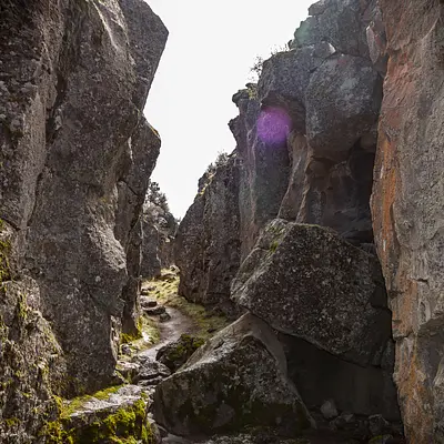
About Crack-in-the-ground
Crack-in-the-Ground is an ancient volcanic fissure over 2 miles long and up to 70 feet deep. Normally, fissures like this one are filled with soil and rock by the processes of erosion and sedimentation. However, because it is located in such an arid region, very little filling has occurred and Crack-in-the-Ground exists today nearly as it did shortly after its formation thousands of years ago. An established 2 mile trail along the fissure’s bottom offers a unique hike, where the temperature can be as much as twenty degrees cooler than at the surface.Know Before You Go:Open Season Crack-in-the-Ground is open YEAR ROUND.Trail Difficulty is moderate, with a 70’ elevation gain and sand and rock surface.Universal Access Restroom available.No drinking water available.Trail open to foot travel only. Motor Vehicles, Mountain Bikes, and Equestrians are PROHIBITED.Access is via rugged dirt roads that may be impassable at times. Four-wheel drive vehicles are highly recommended.Facilities at the Green Mountain facilities include 6 designated campsites, a vault toilet, picnic tables, and fire grates. This is a primitive campground so please pack out all of your trash.The fire lookout atop Green Mountain is manned from June through October.The nearest services are in Christmas Valley, Oregon.Point of Interest:A trail along the fissure's bottom allows for visitors to hike the crack’s length - and cool off, due to a temperature up to twenty degrees lower than the surface.
Activities & Attractions
Nearby

Hiking
Year-round
Year-round
Hiking
Nearby
Campground Amenities
Most popular amenities
Picnic Table
Restrooms
Fire Pit

Water and Hygiene
- Restrooms

Cooking and Fire
- Picnic Table
- Fire Pit
Missing information?
Report Incorrect Information
Help us improve by reporting any incorrect amenity information for Crack-in-the-ground.
Location Crack-in-the-ground
Address:
Lakeview District Office, 1301 South G Street
Lakeview, OR, 97630
United States
Highway access
The campground is accessible via State Highway 140, which is approximately 22 miles to the south.
Latitude & Longitude: 43.3328 / -120.676
Elevation: 1364 feet
Nearby Campgrounds
Nearby destinations
Last updated: July 11, 2026
Managed by Bureau of Land Management