

About John Day Crossing Historic Site
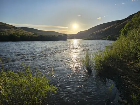
Situated on the east bank of the lower John Day River, this site marks the location where two branches of the Oregon trail converged to meet at the John Day River crossing. Looking up on the hillside, one can see white markers planted to mark the actual routes as they descend the hillside. Imagine trying to keep wagons and stock from plunging down the hillside, unchecked. Some emigrants who descended one branch of the Oregon Trail here are said to have remarked that the other branch must have been better because it could not be worse than the one they descended.Follow the trail markers along the road just above the historic site for ¼ mile to a small interpretive site. Here, one afforded a vantage of the approach of the John Day River crossing. Depending on the time of year one views the crossing, the river’s volume of water can look quite ominous. Most of the journal entries date from the late summer and fall, however, when water levels on this free-flowing river are greatly reduced. Today, a primitive boat launch is used as the last public takeout on the John Day Wild & Scenic River before Tumwater Falls.Know Before You GoOpen year-roundPaved road access via Rock Creek ends at McDonald Ferry Road. This final, 2-mile stretch is unmaintained and impassable when wet or inundated.If traveling to the site via Cedar Springs, check out the interpretive panel at Cedar Springs Ranch, a stopover for Oregon Trail emigrants before the descent to the John Day River. This site is located on private property; please be respectful of this.The site features a small, primitive campsite nestled in a cottonwood grove, picnic tables and a vault toilet.No services, including potable water or garbage service is available onsite—please pack out your trash.An annual fire closure is in effect from June 1 through October 15. Prohibited acts during this closure period include building, igniting, maintaining, attending, using, tending, or being within 20 ft of a campfire, charcoal fire, or any other type of open flame; smoking, except while in non-public buildings, closed vehicles, in boats on the water, or while standing in the water.Point of InterestJohn Day Crossing Historic Site is just one of several Bureau of Land Management historic sites marking significant locations along the 2000-mile Oregon National Historic Trail.
Activities & Attractions
Nearby

Boating
Spring
Summer
Fall

Fishing
Year-round
Hiking
Year-round

Kayaking
Spring
Summer
Fall

Paddling
Spring
Summer
Fall
Year-round
Fishing
Nearby
Hiking
Nearby
Spring
Boating
Nearby
Kayaking
Nearby
Paddling
Nearby
Summer
Boating
Nearby
Kayaking
Nearby
Paddling
Nearby
Fall
Boating
Nearby
Kayaking
Nearby
Paddling
Nearby
Campground Amenities
Most popular amenities
 Picnic Table
 River Access

Cooking and Fire
- Picnic Table

Water Access
- River Access
- Boat Ramp / Launch
Missing information?
Report Incorrect Information
Help us improve by reporting any incorrect amenity information for John Day Crossing Historic Site.
Reviews
0 reviews
Location & Directions for John Day Crossing Historic Site
Prineville District Office, 3050 Ne 3rd St., Prineville, OR 97754 United States
Elevation: 124 ft


Nearby Campgrounds


Nearby destinations

Last updated: October 7, 2026

Need help?
Our team is here to help you find the perfect spot for your next adventure.
Message us
Replies within minutes
Explore Prineville, OR
Population: 11,470
Nearby city: Kennewick, WA
Approx. 75 mi away (straight-line distance)
Elevation: 2,867 ft
Prineville, OR
Weather & Conditions
Loading destination weather
From our Travel Guides

Managed by the Bureau of Land Management