About Aguirre Spring Recreation Area and Campground
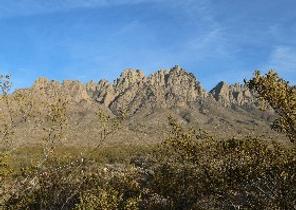
The high wall, needle-like spires of the Organ Mountains curve dramatically around a semicircle of Chihuahuan Desert habitat at the Aguirre Spring Campground. The campground, nestled at the base of spectacular cliffs, overlooks the Tularosa Basin and White Sands National Park. Alligator juniper, gray oak, mountain mahogany and sotol are a few of the abundant plant species here. Seasonal springs and streams occur in the canyon bottoms, with a few perennial springs that support riparian habitats.The Aguirre Spring Recreation area includes a scenic drive along Aguirre Spring Road, two National Recreation Trails and a campground. Baylor Pass Trail is a six-mile (one way) trail that traverses the Organ Mountains from east to west. Pine Tree Trail is a 4-mile loop trail.
Reviews
0 reviews
Location & Directions for Aguirre Spring Recreation Area and Campground
Las Cruces District Office, 1800 Marquess Street, Las Cruces, NM 88005 United States
Elevation: 1,786 ft


Highway access
Aguirre Spring Recreation Area and Campground is accessible via U.S. Highway 70, approximately 11 miles to the south in Las Cruces.

Near White Sands National Park
The closest entrance is: White Sands National Park Entrance Station
Approximate drive: 44.3 mi · over 1 hr (76 min)
Nearby Campgrounds


Nearby destinations

Last updated: October 7, 2026

Need help?
Our team is here to help you find the perfect spot for your next adventure.
Message us
Replies within minutes
Explore Las Cruces, NM
Population: 114,197
Nearby city: El Paso, TX
Approx. 42 mi away (straight-line distance)
Elevation: 3,891 ft
Las Cruces, NM
Weather & Conditions
Loading destination weather
From our Travel Guides

Managed by the Bureau of Land Management