Mcnary Beach – Sockeye Shelter (or)

Reviews

5 reviews

Summary

AI generated

Mcnary Beach – Sockeye Shelter offers a serene environment perfect for mountain biking along an easy gravel road, extending to Hat Rock and Warehouse Beach. The area features enjoyable single track trails for experienced riders, though some sections are near cliffs. Visitors appreciate the peaceful atmosphere and connection to nature, making it a rejuvenating experience.

Based on guest feedback

4.8

Overall rating

Based on 5 reviews

Write a review
5 stars 80.0% (4)
4 stars 20.0% (1)
3 stars 0.0% (0)
2 stars 0.0% (0)
1 star 0.0% (0)

Showing 5 reviews

Sort by: Oldest First
Pacific Northwest Hiking

Pacific Northwest Hiking

May 10, 2022 Google Maps

I actually used this area as a starting point to walk to Hat Rock St. Park. There is a walking trail from here to Hat Rock. It's 5 mi or so to Hat Rock and 5 or so back. The walk is easy on a great paved path. It follows the river and the views are great. I have camped at Hat Rock plenty of times and done this walk from HR to McNary and then gone back to camp. It is every bit of the 10 mi out and back no matter which side you start at. It's a great day walk if you start at McNary. You can hang out in the park and have a picnic before you leave. If you start at Hat Rock you can camp when you get back. Hat Rock is small but it is a state park. Just check in at the main store. They have tent and rv sites, bathrooms,showers, laundry and a store where you can buy food etc. This is a great trail for a family. No elevation and paved.

Helpful

Kishan Prudhvi Guddanti

Kishan Prudhvi Guddanti

February 19, 2024 Google Maps

Went in January and it was so beautiful to see during night with snow! Drive safe because of road conditions and icing

Helpful

Kristy “Kraz” Z

Kristy “Kraz” Z

September 1, 2024 Google Maps

Great little beach. Water is warm, picnic tables are spread out, lots of room to play. Playground up top. Clean area (a trash around).

Helpful

Rho Rho

Rho Rho

September 20, 2024 Google Maps

Only the creator knows how bad I needed to feel nature and made it happen. I was able to Bobtail a couple of miles to the wonderland. Peaceful, clean and full of positive energetic frequencies. Just what my soul needed.

Helpful

Kevin Hollenbeck

Kevin Hollenbeck

November 19, 2025 Google Maps

I only go here to ride my mountain bike. It is a very easy old gravel road, with no cars, which you can ride all the way to Hat Rock, and even on to Warehouse Beach Recreation Area. There are also nice single track trails that parallel the gravel road, but I would only have experienced riders do the single track trails, as some spots along the trail are close to cliffs.

Helpful

Location & Directions for Mcnary Beach – Sockeye Shelter (or)

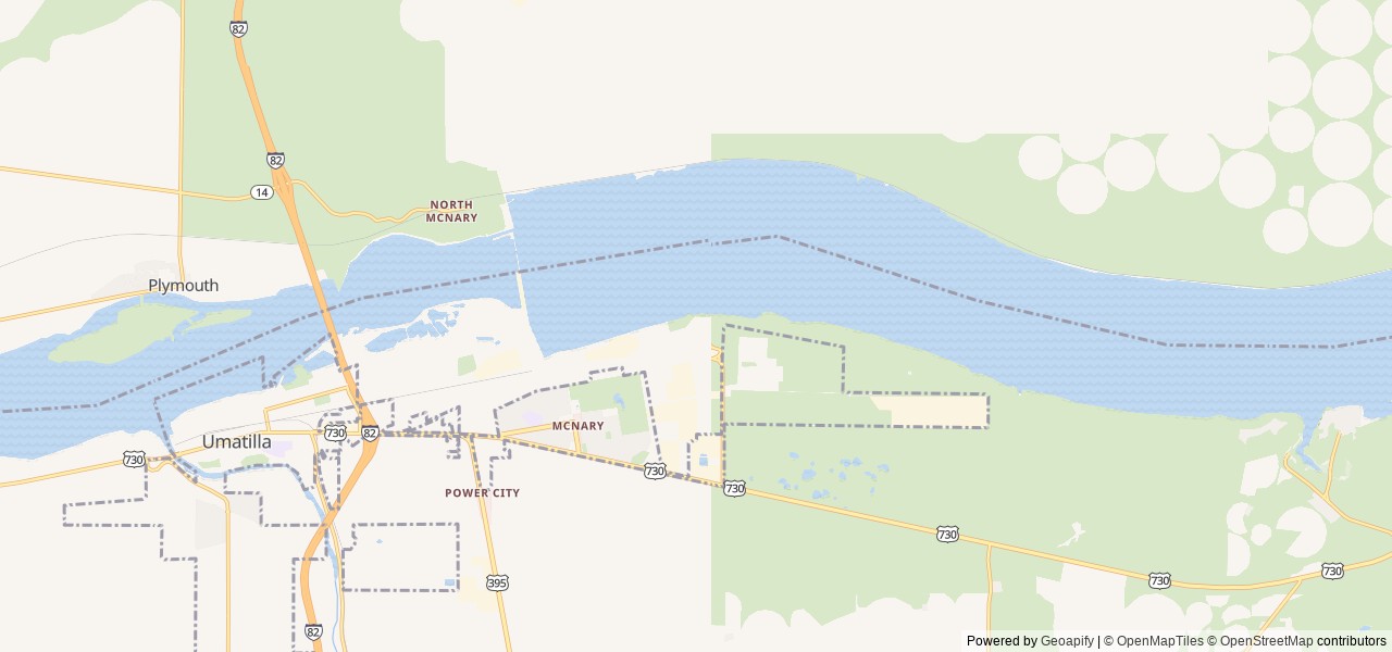
PO Box 1230, Umatilla, OR United States

Elevation: 103 ft

Nearest town

Umatilla, OR - 5.3 mi

About 10 min to downtown

Highway access

The campground is just off US-730. Interstate 84 is a short drive away and US-395 is a short drive away, providing additional regional access.

Nearby Campgrounds

Nearby destinations


Last updated: October 7, 2026

Message us

Need help?

Our team is here to help you find the perfect spot for your next adventure.

Message us

Replies within minutes

Is this your campground?

Explore Umatilla, OR

Population: 7,508

Nearby city: Kennewick, WA

Approx. 21 mi away (straight-line distance)

Elevation: 322 ft

Umatilla, OR

Weather & Conditions

Loading destination weather